logo

Menu

  • Photography Blog
  • Mt. Elizabeth/Mt. Bolton/Lax¯ukw
  • Photo books
  • News and weather
    • Enbridge Northern Gateway
  • People in the news
  • Northwest BC Industries
  • Natural world
    • Wildlife
  • Sea
  • Lakes, rivers and wetlands
  • Land
  • Photo Services
    • Portrait photojournalism
    • Commercial photography
    • Guides and outfitters
    • Photo printing
    • Photo books
  • Bio
  • Contact

Recent Posts

  • From my archives: Birds in Montserrat
  • A blue moon in August
  • Summer birding photos in Kitimat
  • Smoky moon over Kitimat
  • Mt. Elizabeth/Mt. Bolton/Lax¯ukw

RSS Model making and diorama photography

  • Galactic Tramp: Kitbashing Andre Norton’s Solar Queen from the Luna Rocket ship
  • A cold, wet winter on Arch-to
  • Dollar Store Dinosaurs
  • Star Wars #ourgreatindoors
  • The Rusty Romulan

Posts Tagged “LNG”

August Sturgeon Super Moon over Kitimat

August Sturgeon Super Moon over Kitimat

Super moon over Kitimat BC at 5:15 am, August 2, 2023. Most of the lights are from the LNG Canada construction project. (Robin Rowland)

Black and white version of the same super moon shot (Robin Rowland)

August sturgeon super moon over Kitimat, 5:13 a.m. August 2, 2023. (Robin Rowland)

The supermoon over Kitimat and the LNG project earlier at 4:30 a.m. (Robin Rowland)

Waxing 97 per cent super moon rising over Kitimat, July 31 (Robin Rowland)

Sunset over Kitimat and Douglas Channel, July 31, 2023 (Robin Rowland)

August 2, 2023 Robin Rowland
Alpha 55, black and white, Douglas Channel, Kitimat, landscape, moon, night, Photography, Sony RX10iiiBlack-and-white , British Columbia , clouds , construction , Douglas Channel , Kitimat , LNG , LNG Canada , Moon , Sturgeon moon , sunset , super moon

Portraits of the speakers at the Kitimat The North Matters forum

The North Matters group held a forum, LNG Myths, Facts & Benefits in Kitimat, BC, on May 2, 2018.

Here are the portraits of the speakers.

Fort. St. John, BC, Mayor Lori Ackerman. (Robin Rowland)

Elected chief counsellor of the Haisla Nation Crystal Smith (Robin Rowland)

Kitimat Mayor Phil Germuth. (Robin Rowland)

Energy blogger Vivian Krause. (Robin Rowland)


May 3, 2018 Robin Rowland
Alpha 7II, Kitimat, LNG, Photo gallery, Photoblog, Photography, Photojournalism, pipeline, politics, Sony RX10iiiBritish Columbia , Crystal Smith , Haisla , Haisla Nation , Kitamaat Village , Kitimat , LNG , Lori Ackerman , North Matters , Phil Germuth , Photo gallery , photoblog , Vivian Krause

Preparing the Pacific Trail Pipeline right of way

Preparing the Pacific Trail Pipeline right of way

pipelineslashwedeene1bw

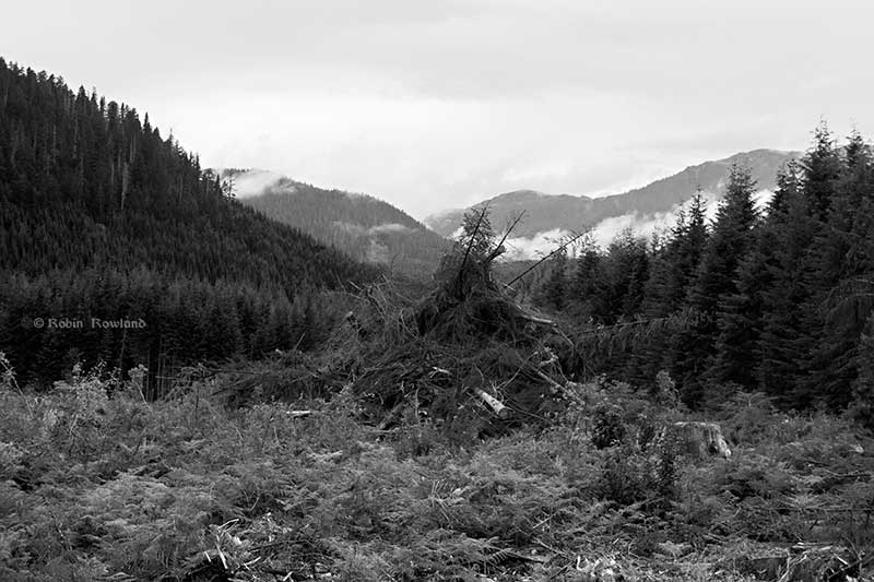
A pile of log slash stands on the route of the Pacific Trail Pipeline, the first route to Kitimat, BC, to see preliminary construction. The 480 kilometre natural gas pipeline will deliver gas from Summit Lake, B.C. to the proposed Kitimat LNG facility site at Bish Cove on Douglas Channel south of Kitimat. (Robin Rowland)

The Pacific Trail Pipeline and its route was originally approved by British Columbia in 2006, as part of an earlier project to import, rather than export, natural gas.

The proposed Enbridge Northern Gateway Pipeline will follow a similar route to the Pacific Trail Pipeline, but as opponents of the Gateway project pointed out during the Joint Review Panel hearings, PTP has the original and optimum route through the rugged mountain territory. The clearing of the right of a way has led to false rumours that the work is for Northern Gateway.

PTPHoultsignbw

A Pacific Trail Pipeline sign is seen on the Houlte Forest Service Road near a washout on Houlte Creek, where the pipeline cross the mountains.(Robin Rowland)

PTPHunder1bw

The pipeline route near Hunter Creek on the Upper Kitimat River Forest Service Road was cleared a year or so ago and there is already new undergrowth. (Robin Rowland)

ptpweedene1bw

The right of way along the Little Wedeene Forest Service Road was cleared this year. (Robin Rowland)

twistedstumpwedeenebw

A twisted stump beside the road shows the scars of slash burning and rot. (Robin Rowland)

pipelineslashwedeene2bw

The slash pile is at the site of a quarry near the Little Wedeene River, which will harvest glacial aggregate for use along the pipeline route. (Robin Rowland)

slashwedenne2bw

Part of the quarry site borders on an wetland which was also cleared. (Robin Rowland)

slashwedenne1bw

A jumble of branches at the quarry site. (Robin Rowland)

stumpwedeene1bw

A stump beings to rot away at the quarry site near the Little Wedeene. (Robin Rowland)

slashstumpwedeenebw

A stump at the quarry site shows scars of slash burning, rot and fresh growth of ferns. (Robin Rowland)

The final burning of the slash piles was postponed at the height of the summer drought June, July and early August.

slashstump1bw

A couple of old stumps at the quarry site. (Robin Rowland)ptp-map-dec6-2014


The route of the Pacific Trail Pipeline (Chevron/Woodside/Pacific Trail Pipeline)

September 7, 2015 Robin Rowland
black and white, forest, Instagram, Kitimat, landscape, Photography, pipelineBlack-and-white , British Columbia , Kitimat , Kitimat LNG , LNG , mountain , Pacific Trail Pipeline , pipeline

A rainy evening at Bish Cove, site of the KM LNG project

475-Bish-Cove-July-27-_4bw.jpg

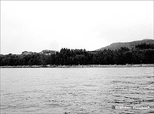
Bish Cove, down Douglas Channel from Kitimat, is the site of the $3 billion liquified natural gas terminal, the KM LNG (Kitimat LNG facility) project, which could see LNG exported from the proposed giant terminal on tankers to Asia.

At the moment, Bish Cove is only accessible by boat and helicopter.   The stormy evening of July 27, 2011 was not the best for taking photos, with heavy overcast, constant rain, fog  and smoke on the mountains.  It was the first time I was able to visit Bish Cove since the preliminary construction project began.

476-Bish-Cove-July-27-_1bw.jpg

Construction has just begun and there is no road. Smoke is from burning slash from cleared bush.  The next step in the project is to blast the bare rock hillside behind the beach to the left down to close to sea level.

477-Bish-Cove-July-27-_2BW.jpg

478-Bish-Cove-July-27-_3bw.jpg
The cinder blocks on the beach are the first steps in building a wharf.

479-Bish-Cove-July-27-_5bw.jpg480-4703373621_a6ab2a7b83_m.jpg

481-4704011126_ba24096c97_m.jpg

KM LNG artists’ conceptions of how the site in the photographs will eventually look. (Courtesy KM LNG)

Coverage of energy and environment on the northwest BC coast by Robin Rowland in Northwest Coast Energy News.

July 28, 2011 Robin Rowland
seascapeBlack-and-white , Douglas Channel , Kitimat , Kitimat harbour , KM LNG , liquified natural gas , LNG , ocean , rain , smoke

Archives

Archives

Search

All images Copyright © 2023 By Robin Rowland. All Rights Reserved.
WordPress Themes Copyright © 2017. by Web-Dorado