The Slave Traders’ Pilot Book
Captain’s log 18191029
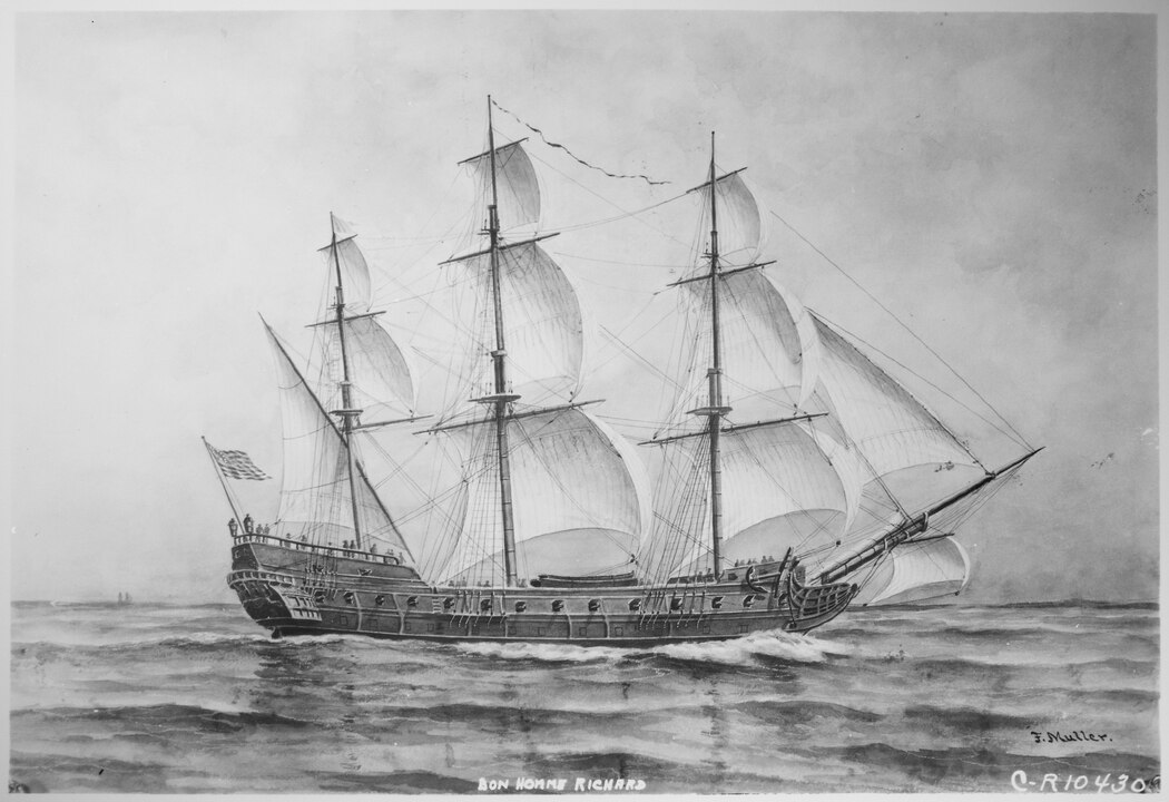
It was October, 1819. The Royal Navy sloop HMS Pheasant part of the new anti-slavery West Africa Squadron, was on patrol off Accra in what is today Ghana.
For the research and writing on my latests book project, I was reading the log and came across a reference that I had not seen before. The captain, Commander B. Marwood Kelly mentioned that he was using “Dalzel’s Guide” to the African coast. (That is how Kelly signed his logs and reports, not using his first name Benedictus as most histories say)
I set out to find out Dalzel’s guide was. It turned out to be a bit more challenging than I thought.
Archibald Dalzel was easy to find online. He was one of the most notorious slavers who operated out of Liverpool and one of the propagandists promoting the Atlantic slave trade although it is likely he believed his racist attitude that slaves were better off in the Americas than in Africa because they did not, in his view, face human sacrifice. In reality of course, tens of thousands of enslaved worked to death, sacrificed on the altar of capitalist greed.
His book, The History of Dahomy, has been studied by historians and scholars for decades because it justifies slavery and colonialism. It is available in modern reprints. Many of the online entries on Dalzel don’t mention “a guide” but some did, a volume called New Sailing Directions for the Coast of Africa; Extending from Cape Spartel…to the Cape of Good-Hope, And of the African Islands Situate in the Atlantic and Ethiopic Oceans.
Sailing directions have guided mariners for thousands of years. The advice that both Circe and Calypso give to Odysseus are believed to be Homer’s adaptations of poetic guides for the sailors in the Mediterranean. Songs of the indigenous people of the Pacific northwest, recorded in the late nineteenth and early twentieth centuries are sailing directions and storm warnings.
“Pilots” or “sailing directions” began with the invention of the printing press in Europe and were published by both private printers and governments beginning in the middle of the sixteenth century.
I checked Worldcat and found out there were only five copies existing in public institutions.There are just five copies of the Sailing Directions that survive in public institutions: Northwestern University Library in Evanston, Illinois, the New York Public Library, Yale University, the University of Birmingham and the University of the Witwatersrand.
The New York Public Library’s premier centre for Black studies in the US, The Schomburg Center for Research in Black Culture in Harlem was unable to help. At the time, due to staff and budget cuts they weren’t scanning items for researchers outside of New York. Northwestern University in Evanston and Chicago, Medill School of Journalism, Media, Integrated Marketing Communications has one of the best journalism programs in the United States, and there with the help of the faculty hire a student, Kadin Mills, who retried the book and sent me a scanned copy.
My search found a long forgotten aspect of the history of the slave trade. In the last decade of the eighteenth century, the slaver captains of Liverpool united to create their own sailing directions for Africa. The book was printed first in 1799 and reprinted in 1804, just three years before the British Parliament outlawed the North Atlantic slave trade. The South Atlantic slave trade continued and that is the subject of the overall book, where my fourth great grandfather William Pennell, the British consul, in Bahia, Brazil spied on the slave traders.
The Sailing Directions was still the definitive guide to the coast of west Africa. That is why the anti-slavery Royal Navy West Africa Squadron used the guide as their sailing directions. Dalzel et al’s directions if it was available would continue to be use until the 1850s, when there were new surveys and an Admiralty Pilot was printed in 1853.
Admiralty Pilots updated of course, are still in use today by mariners worldwide and in the age of GPS and computers still offer advice, some of it ancient and as well as 21st century best practices and situational awareness.
Each volume of Sailing Directions offers:
- Information on navigational hazards, buoyage, pilotage, regulations, general notes on countries, port facilities, seasonal currents, ice and climatic conditions. This information, when used alongside official Admiralty charts, can help to increase situational awareness on the bridge
- High quality diagrams and photography to help bridge-crews understand critical information during the passage planning stage
- Worldwide official coverage to support safe and compliant navigation within main commercial shipping routes and ports. This coverage is split across 76 volumes for purchase flexibility
My brief article “The Slave Traders’ Pilot Book” was just published in TopMasts the online magazine of the Society for Nautical Research.
(This URL may change as the Society launched its new website today along with the new issue of the magazine. I will update the URL as necessary)
As my research and writing on the overall book continues, with hundreds of handwritten documents and other short term paying assignments and life, it is taking a long time, probably another year to write the first draft.
There will be another “long forgotten” article about another subject, a forgotten ship, in a different nautical journal later this year.
Robin