Posts Tagged “river”
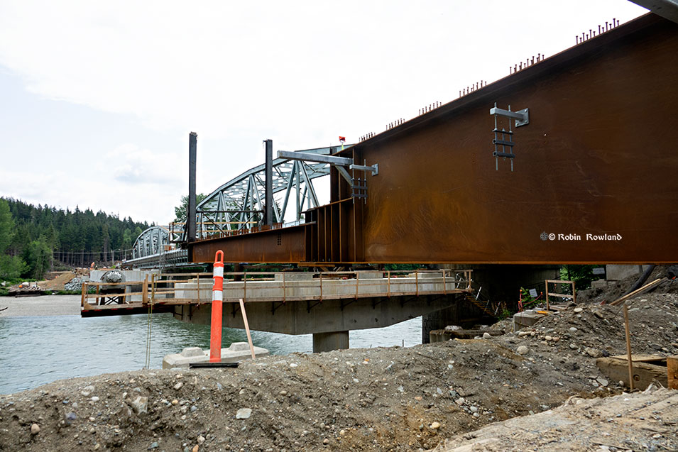
The Haisla Bridge Replacement Project, Girder Launching Ceremony, June 14. 2022. Pylons anchored deep into bedrock of the Kitimat River will soon be mounted with giant steel girders. The new bridge project is expected to be completed by spring, 2023, then the old bridge from 1953 with its familiar humming vibration on the old deck will be demolished.
The 38.5 mile (62 kilometre) Canadian National Railways branch line from Terrace to Kitimat is one of the last working rail lines in North America that still uses wooden trestle bridges.
There are three large and three smaller trestles along the line, as well a large bridge built to cross the Skeena River at Terrace and three steel Pratt triangular truss bridges over the Lakelse, Wedeene, Little Wedeene Rivers.
Additional photographs are by Jim Thorne. All rights reserved. Jim also added some historic information for this blog.
In the late 1940s, the Aluminum Company of Canada (Alcan) began planning a smelter in Kitimat, to take advantage of the hydro electric capacity that would eventually lead to the reservoir behind the Kenney Dam that fed water through the mountains to the power plant Kemano.
As Alcan was planning and building Kitimat, the company signed transportation contracts with Canadian National Railways promising the railway would get one million 1950 dollars a year in revenue.
The branch line had go through the rugged terrain, come in to the town’s service centre, pass what was then an obstacle known as the Sand Hill and then on to the new aluminum smelter. (The Sand Hill, a glacial deposit, then reached all the way to the Kitimat River. For the past 60 years it has been used to support the local industries by supplying sand, gravel and concrete products and has now shrunk back from its original size.)
CN worked to build the new branch line crossing “difficult terrain of the area, including swamps, hard clay, rocks and watersheds.”
Canadian Transportation magazine reported in July 1952 that the branch line alone would cost $10 million 1952 dollars or $217,391.30 per mile.
Freight travel began as soon as the branch line was completed in December 1954. Temporary huts acted as the train station when passenger service began in January 1955 but were soon overwhelmed. A CN Station was built that would operate until passenger service ended in 1957 when the highway to Terrace was opened.
RELATED Can Kitimat’s historic CN railway station be saved from demolition?
The “milk-run” freight trains were restricted to a maximum speed of 15 miles per hour (it’s 20 mph today) over the Kitimat Sub Division. Along the line CN serviced Lakelse Lake where there was a whistle stop in a clearing by the track. I still remember a vacation at Lakelse in the summer of 1957 when I was seven years old. Seeing the steam locomotive come around a curve out of the forest for the return journey was the moment I fell in love with trains and railways. The other “stations” (again really just clearings) on the timetable were at Wedeene, Dubose and Thunderbird, to pick up loggers, surveyors, fishers and hunters. The trip from Lakelse to Kitimat would have taken one hour and thirty minutes if the passenger train was running on schedule
Though passenger service is long gone, freight service has continued now for more than 60 years. Freight traffic increased in the early 1960s, then slowed as the market for aluminum slowed down. Freight traffic on the line peaked in the years when the Eurocan Pulp & Paper mill was operating (1969 – 2010). Wood chip cars comprised a major portion of traffic on the line. More traffic was added when Ocelot Industries (later owned by Methanex) came on line in the 1980s. In 2010, Eurocan closed and more than half the traffic on the line was lost. Then the Methanex traffic also came to a halt. Today, almost all of the remaining traffic is for Rio Tinto (the successor to Alcan). But CN may soon see new customers on the Kitimat Sub Division.
Today traffic is on the increase with the multi-billion dollar LNG Canada project beginning construction. There is a second smaller liquefied natural gas project planned. As well there is the proposed Pacific Traverse Energy liquefied petroleum gas project which would use tank cars rather than the pipelines planned for the LNG project. That means those more than 60-year-old trestles will even more trains in the future. Those trestles were rebuilt and reinforced in the 1990s to increase load capacity. In 1997, part of the Thunderbird ‘S’ trestle collapsed while being rebuilt and there was a fatality and several serious injuries.
Over the past few months, I set out to photograph those trestle bridges that are accessible. Some of them are deep in the bush and others can only be reached by boat.
The first challenge for CN was the main line was on the north bank of the Skeena River. First built as part of the old Grand Trunk Pacific, the line followed the river through Terrace and then on to the port of Prince Rupert. To reach Kitimat and hemmed in by mountains, CN had to build a switch back so that the trains would go into the Terrace yards, then switch onto the Kitimat branch line. That meant a new rail bridge had to be built alongside an older highway bridge.
Our track showing the road along the river south of the Wedeenes. There are three trestles, a small one over an unnamed creek, a larger one over Goose Creek and a third inside Kitimat beside Ninth Street.
RELATED Can Kitimat’s historic CN railway station be saved from demolition?
A great blue heron sits on some debris in Kitimat harbour, during my annual visit to the estuary for the Christmas bird count, Dec. 14, 2014. (Robin Rowland).
There was more late afternoon light than last year . On the other hand, while my birdwatching colleagues did list lots of species around the area, the photographic opportunities this year were mostly limited to great blue herons and Canada geese.
Trumpeter swans in the oxbow of the Kitimat River. (Robin Rowland)
Kitimat’s iconic Mt. Elizabeth seen from a lagoon in the Kitimat River estuary. (Robin Rowland)
A Canada goose in a lagoon in the Kitimat River estuary. (Robin Rowland)
A duck in the estuary. (Robin Rowland)
Ducks sheltering the reeds of the Kitimat estuary. (Robin Rowland)
A great blue heron comes in for a landing in the Kitimat River estuary, with some Canada geese watching. (Robin Rowland)
A great blue heron contemplates the Kitimat River estuary. (Robin Rowland)
Canada geese grazing in the Kitimat River estuary. (Robin Rowland)
Another view of the lagoon in the Kitimat River estuary. (Robin Rowland)
Birds at Christmas time in Kitimat 2012
Christmas bird count, Kitimat river, estuary and harbour Dec. 17, 2011
Driving back to Kitimat from Prince Rupert on the afternoon of September 29, 2014, I stopped, as I often do, at the Basalt Creek rest area. Took a few shots of the Skeena and the railway tracks for a story I was working on about pipelines along the river. Then out of the corner of my eye I spotted some mushrooms growing on an old stump, catching the light filtered through the rain clouds. Remember those childhood tales of fairies perching on mushrooms, with these you can almost imagine there were fairies on those shiny edges just above the rain drop. (Robin Rowland photos)
The sun sets over the Kitimat River and the snow covered Sand Hill, in Kitimat, BC, February 20, 2014. Converted to black and white using Perfect Effects 8 to emulate Ilford FP4125, with some highlights and shadow enhancement. (Robin Rowland)
Original image. The sun sets over the Kitimat River and the snow covered Sand Hill, in Kitimat, BC, February 20, 2014. (Robin Rowland)
The oolichan, the tiny oil rich fish that sustained the First Nations of British Columbia for millenia come up the rivers in the early spring. At least they come up those rivers where oolichan (Thaleichthys pacificus) still survive. Like the salmon, the oolichan live their adult lives in the ocean and then return to their native streams to spawn and die.
One of the rivers that still sees an oolichan run is the Skeena. Gulls, eagles, ravens, seals all come to feast as the oolichan migrate upstream. The gulls, sensing a feast after a long, harsh winter, are almost in a frenzy, circling and diving over the spot in the river that the oolichan migration has reached.
On Friday, March 8, I was driving to Prince Rupert for an assignment and stopped at the Telegraph Creek rest area. I was lucky, for it was at Telegraph Creek, a great spot for photographs, that the oolichan had reached. There were a few naturalists at Telegraph Creek watching the show. It was an elderly couple who first clued me in to what was going on. Thank you.
Mostly gulls. An eagle flying overhead. Seals or sea lions just upstream.
If I didn’t have that assignment I had to get to in Rupert, I would have stayed at Telegraph Creek most of the day. But as it was, I did manage to get a few shots of the hundreds of gulls circling, wheeling and swimming. I got a couple of not very good shots of an eagle overhead (not very good which is why they’re not here) and the seals or sea lions weren’t anywhere close. So I stayed as long as I could, then it was back in the car for work.
After three weeks of constant rain, triggered by one Pineapple Express weather system after another, the sun finally began come out late last week and I was able to shoot some of the spectacular fall colours around my new (and old) hometown of K|itimat.
While northwestern British Columbia is mainly forested by conifers, poplars and other deciduous trees hug the river banks and often appear in small groves on the mountain slopes.
So after three weeks of this (which a lot of long term residents say is unusual even for Kitimat)
The sun finally came out and you could see the spectacular yellow along the Kitimar River.