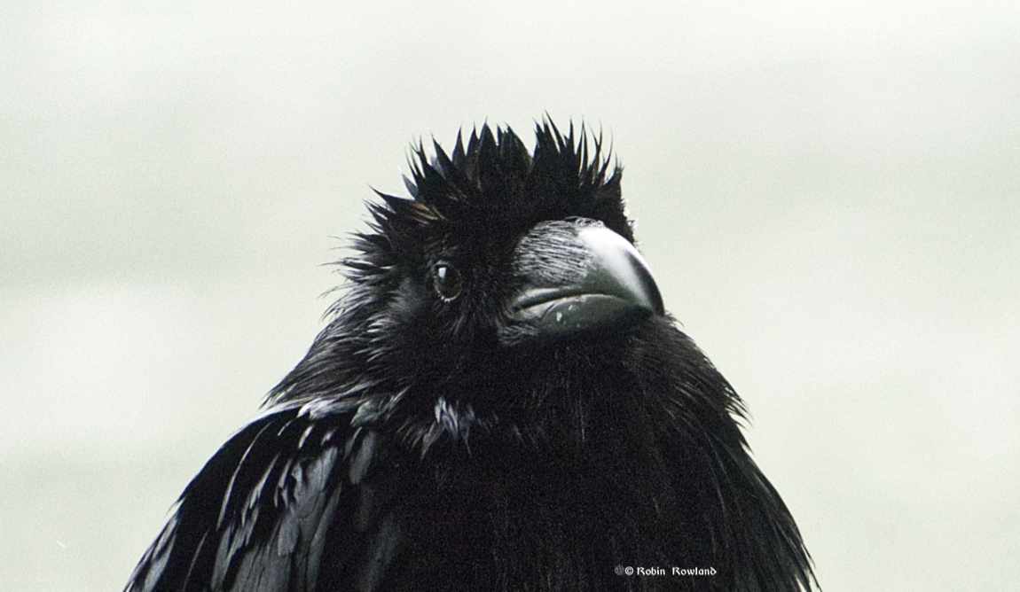
logo

Menu

  • Photography Blog
  • Photo books
  • News and weather
    • Enbridge Northern Gateway
  • People in the news
  • Northwest BC Industries
  • Natural world
    • Wildlife
  • Sea
  • Lakes, rivers and wetlands
  • Land
  • Photo Services
    • Portrait photojournalism
    • Commercial photography
    • Guides and outfitters
    • Photo printing
    • Photo books
  • Bio
  • Contact

Recent Posts

  • A mink on a log. How I got the shot (plus some bald eagles)
  • Canada Geese overhead
  • “It’s not a costume” Racism protest in Kitimat
  • Bald eagle at Minette Bay
  • Great blue heron on Kitimat waterfront

RSS Model making and diorama photography

  • A cold, wet winter on Arch-to
  • Dollar Store Dinosaurs
  • Star Wars #ourgreatindoors
  • The Rusty Romulan
  • Hot chicken Jedha

Posts Tagged “Skeena River”

Super tide on the Skeena

"Super" low tide on the Skeena River at Telegraph Point, Sept. 28, 2015 (Robin Rowland)

“Super” low tide on the Skeena River at Telegraph Point, Sept. 28, 2015 (Robin Rowland)

I had great plans for shooting the super moon and the eclipse blood moon on Sunday night, September 27. Unfortunately the ideal shot of the moon rising over our iconic Mt. Elizabeth (which I have captured in the past) was impossible, there was a storm blowing in, and the overcast was so heavy that dark moon wasn’t even visible.

But today, I captured the related super tide –at low tide–which is the shot, I am sure, no one was looking for. To be honest, I was trying to shoot fall colours on a gloomy day where the Skeena lives up its original in name in the language of the Tsimshian First Nation, K-shian, “water that falls from the clouds,” also translated as “river of mists” and now is colloquially called “the Misty River.”

I was amazed at the Skeena was so flat, and so low at a time when it had been raining for the past couple of days and should have been much higher.

A few hours later when I was driving  back from Prince Rupert, in a pounding rain and wind storm, the river was actually higher than I had ever seen it before.

I didn’t realize what I had until I was watching  the weather segment on the CBC National, and the Weather Network presenter mentioned there was a super tide.  Google checks confirmed that a super tide accompanies a super moon.

supertidetelegraphpoint1


Telegraph Point, on the Skeena, taken at 1135 hrs on September 28.

Telegraph Point is about 44 kilometres (27 miles) inland from where the Skeena reaches the Pacific Ocean, and the tides do reach even further inland than that.   Low tide at Prince Rupert  was at 0811 on Monday. There aren’t tide tables this far inland (not needed for sailors)
supertidetelegraphpointhi1

As I arrived for an  appointment in Prince Rupert, it started to rain. By the time I had completed my appointment and had had lunch, I drove back in a wind driver rain storm. I stopped briefly at Telegraph Point and grabbed some quick shots.

This shot, roughly the same angle as the first low tide shot,  was taken at 1457, just after high tide at Prince Rupert at 1426.  You can’t see it in a still image, but  in the river the water was moving rapidly upstream.

supertidetelegraphpointhi2

This was taken at 1512 from the same spot as the first low tide shot.

supertidetelegraphpointhi3

Another angle from Telegraph Point taken during the storm at 1512.

(All images above taken with Sony Alpha 55)

memorialsitelo1

This was one of my first shots of the day, taken about 25 kilometres further upstream at 1101. (taken with Sony Alpha 6000)

Related

Shots of fall colors along the Skeena, October 16, 2014.

Tide tables for two closest points on the Skeena

Current tide for Kwinitsa Creek

Current tide for Khyex Point 

Supermoon means supertides

Supermoon 2015 to cause highest ‘super tides’ for 19 years (Independent UK)


September 28, 2015 Robin Rowland
Alpha6000, fall, nature, Photo gallery, Photoblog, Photography, rain, Skeena River, skyBritish Columbia , clouds , fall colors , landscape , mountain , rain , Skeena River , storm , tide

Fall colours along the Skeena

Fall colours along the Skeena

Cottonwood and alders along the Skeena

The falls colours along the Skeena can be fleeting. For a while the cottonwoods are changing, while the alders remain green or begin to change to yellow. A few days later, the time I drove along the Skeena in the middle of October 2013, the tall black cottonwoods have quickly lost their leaves, while the alders (and occasionally birch) along the river banks shine bright yellow in the afternoon sun.

Fall colours on the Skeena

Loon on the Skeena

Fall on the Skeena

Far from the sea, a seal (front right) swims up the Skeena, Oct. 16, 2013.

Fall colours on the Skeena

Bare cottonwoods on the banks of the Skeena

Bare black cottonwoods on a beach along the Skeena.


Bare cottonwoods on the Skeena

skeenafall_2_3

The bare cottonwoods
skeenafall_2_4

Sun sets on the Skeena

The sunsets on the Skeena near Terrace, BC, Oct. 16, 2013.

October 18, 2013 Robin Rowland
BC, birds, landscape, Skeena River, sky, sunsetalder , Bird , British Columbia , cottonwood , mountain , Skeena River , sunset

Storm warning on the Skeena

Storm warning on the Skeena
Storm over the Skeena River

Menacing clouds over the Skeena River, looking west from near the Khyex River (Robin Rowland)

On Thursday, October 3, I drove to Prince Rupert for an appointment. With heavy cloud cover on the way into to Rupert I didn’t get much of a chance to shoot the fall colours which are just beginning to peak on some parts of the Skeena (but not everywhere, due to micro-climates you can drive through bright yellows and then a few kilometres further on it’s all still green).

Appointment over and after a hearty seafood lunch at Cow Bay, I headed back to Kitimat, listening on the car radio to the storm warnings and wind warnings from Environment Canada for yet another major early fall storm approaching the BC coast. It was soon apparent from the darkening skies that you didn’t need an Environment Canada weather warning that a storm system was moving in.


Storm over Kaien Island

Stormy weather at the Port Edward turnoff on the east side of Kaien Island, looking west. (Robin Rowland)

Prince Rupert is on the northwest corner of Kaien Island. Highway 16 skirts the the west end of the island until you come to the bridge to the mainland where the highway will either go east to Terrace or south to Port Edward. At the viewpoint just before the bridge, you could see the gathering storm. (By the way there was no rain at all during the time I was driving back and stopping at various points to shoot).


Storm over the Skeena

Storm over the Skeena, looking east at Basalt Creek. (Robin Rowland)

Stormy weather on the Skeena

Stormy weather on the Skeena, at Basalt Creek, looking south across the river. (Robin Rowland)

Just a few kilometres further on, despite the dark skies, the Skeena was flat calm. Those pictures in the next blog.

October 4, 2013 Robin Rowland
landscape, Photoblog, Skeena River, sky, stormBasalt Creek , Bird photography , clouds , Kaien Island , Khyex River , landscape , mountain , Skeena River , storm

Archives

Archives

Search

All images Copyright © 2019 By Robin Rowland. All Rights Reserved.
WordPress Themes Copyright © 2017. by Web-Dorado